Voyager 1: where is it right now?
Voyager 1 is the most distant human-made spacecraft. It crossed the heliopause in 2012 and continues through interstellar space. Here you can follow its calculated current position, distance from Earth, speed relative to the Sun and radio signal travel time. The tracker uses stored JPL Horizons trajectories; instrument status is checked separately against dated NASA reports.
Instrument status checked ·
Where is Voyager 1 now?
The values are calculated from locally stored JPL Horizons state vectors. They are not live telemetry or figures copied from a news article.
Voyager 1
- From the Sun
- — AU
- Speed relative to the Sun
- — km/s
- Change in distance from Earth
- — km/s
- Signal to Earth
- —
- Round trip
- —
- Distance travelled today
- — km
- Relative to escape velocity
- —×
- Relativistic time difference
- — s
- Apparent magnitude of the Sun
- — mag
- Remaining Pu‑238
- — %
- Mission duration
- —
- Distance travelled since page load
- 0 km
- Launch
Calculation for current UTC. The position is interpolated from daily geometric JPL vectors; it is not direct telemetry.
Position and velocity use JPL Horizons; instrument status is a separate, manually verified record. Read the methodology · NASA/JPL — Horizons documentation
Two active science instruments
The current set comes from the latest specific NASA/JPL operations update.
MAGMagnetometer
Measures the strength and direction of magnetic fields.
PWSPlasma Wave Subsystem
Records plasma waves in the interstellar environment.
LECP was switched off on 17 April 2026 to conserve power, leaving MAG and PWS operating. NASA/JPL says both Voyagers lose about 4 watts of available electrical power each year, so the team progressively shuts down heaters, systems and instruments while protecting the spacecraft from temperatures that could freeze fuel lines.
How far is Voyager 1 from Earth?
The main distance in the tracker is the geometric separation between Voyager 1 and the centre of Earth at the stated time. The distance from the Sun appears separately. Neither value is the total path travelled since launch: a spacecraft's route can bend during planetary flybys, while a distance measures the separation of two points.
An astronomical unit (AU) is exactly 149,597,870.7 kilometres. It provides a convenient scale for these enormous distances. A light-day is about 25.9 billion kilometres, the distance light travels in 24 hours. For today's Voyager 1 distance in kilometres or AU, use the changing tracker values rather than a number copied into an article.
How fast is Voyager 1 travelling?
Voyager 1's speed depends on the chosen reference frame. Here the speed is relative to the Sun, while the change in distance from Earth is a separate radial quantity. To express a speed in kilometres per hour, multiply the kilometres-per-second value by 3,600. This conversion does not change the reference frame.
Earth moves around the Sun, so the Earth–Voyager distance can decrease during part of a year even as the probe continues outward. A negative change in Earth distance is therefore compatible with an outward journey. Compare the speed row and the Earth-distance change row instead of treating them as interchangeable measures.
How long does a signal from Voyager 1 take?
The one-way signal time describes a radio signal travelling from Voyager 1 to Earth. A command must also travel from Earth to the probe before a reply can return. The round-trip value covers both journeys; it does not include the spacecraft's processing time, waiting for an antenna or delays in mission operations.
The calculation accounts for the motion of Earth and Voyager 1 during transmission. It is an estimate from trajectory data, rather than a timer measuring the arrival of a particular message. This is why the page distinguishes a continuously calculated position from live spacecraft telemetry. The light-day countdown marks a distance threshold, not the remaining lifetime of the mission.
Two views of the Voyagers’ journey
Snapshot at
Direction on the sky
- Right ascension
- 17.244ʰ
- Declination
- 12.154°
- Constellation · IAU
- Ophiuchus (Oph)
This all-sky map shows the direction from Earth’s centre to both spacecraft. The highlighted point is this Voyager. Right ascension increases to the left; declination is the angle above or below the celestial equator. This map does not determine visibility above your horizon.
Trajectories from the side
- X
- -32.175 au
- Y
- -136.903 au
- Z
- 99.052 au
Ecliptic plane · Z = 0
Looking along the X axis onto the Y–Z plane shows the trajectories relative to the Sun and the J2000 ecliptic plane. Both axes use the same linear scale in astronomical units. Straight segments connect trajectory samples; this is not a detailed view of planetary flybys.
How to read the maps and their data
Sky coordinates come directly from the JPL Horizons observer table: astrometric ICRF, with light travel time included. The side view uses geometric heliocentric vectors sampled every 60 days and an endpoint at the stated date. This is a dated ephemeris snapshot including predicted trajectory, not live telemetry. No extrapolation is used.
Voyager 1 at a glance
- Launch
- 1977-09-05 · 12:56:01 UTC
- Launch site
- Cape Canaveral · Launch Complex 41
- Launch vehicle
- Titan IIIE-Centaur
- Spacecraft mass
- 721.9 kg
- Planetary targets
- Jupiter · Saturn
- Selected closest approach
- Jupiter: 1979-03-05 · ~280,000 km
- Final planetary encounter
- Saturn: 1980-11-12 · ~126,000 km
- Heliopause
- 2012-08-25
- Active instruments
- MAG · PWS
- Mission status
- Extended mission · active
Launched second, reached the planets first
Voyager 1 launched sixteen days after Voyager 2 but followed a faster, shorter route to Jupiter and Saturn, overtaking its twin on 15 December 1977. The close Titan flyby was a major objective. Its geometry sent the spacecraft north of the ecliptic after Saturn, providing the desired Titan observations but preventing later encounters with Uranus or Neptune.
Jupiter: a ring and two new moons
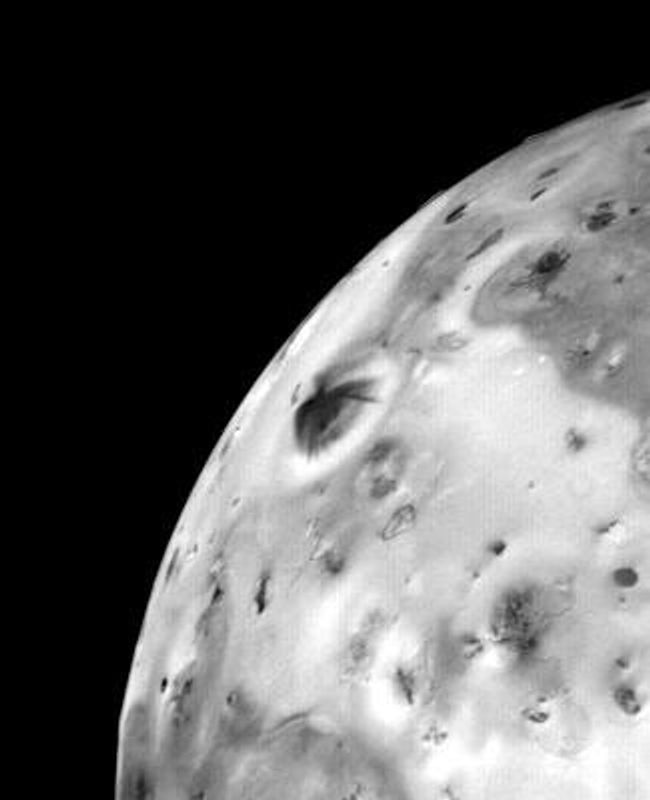
Closest approach occurred at 12:05 UTC, about 280,000 kilometres from Jupiter. Voyager 1 imaged the planet and the moons Amalthea, Io, Europa, Ganymede and Callisto, revealed a faint Jovian ring and discovered the moons later named Thebe and Metis. The Voyager mission also produced the first observation of active volcanism beyond Earth, on Io.
Saturn and Titan changed the onward route
Voyager 1 passed Saturn at 23:46 UTC from roughly 126,000 kilometres. NASA credits the encounter with five new moons, the G ring and complex ring structures including shepherding moons. Titan’s dense atmosphere hid its surface and contained abundant nitrogen, methane and more complex hydrocarbons; the Titan trajectory then carried Voyager 1 out of the planetary plane.
What the measurements changed
Io: active volcanism beyond Earth
- Knowledge before the measurements
- Active volcanoes had not yet been observed on another world. Io was a known moon, but this activity was not an established observation.
- Documented result
- In 1979, a Voyager 1 optical-navigation image revealed an erupting plume above Io. The mission recorded direct evidence of active volcanism.
- Scientific significance
- Io’s surface was undergoing active change during the encounter. The conclusion came from observed activity, not only from the appearance of old landforms.
Evidence: NASA — Io: Exploration · JPL — Edward Stone Voyager Exploration Trail · NASA Photojournal — Io Volcanic Eruption
Jupiter: the first images of its rings
- Knowledge before the measurements
- There were no direct images of Jupiter’s ring system before the Voyager observations.
- Documented result
- Voyager 1 captured the first images of the planet’s faint ring system in 1979.
- Scientific significance
- The images established a ring system as an observed part of Jupiter’s surroundings and provided a target for later investigation.
Evidence: JPL — Edward Stone Voyager Exploration Trail · NASA — Voyager Fact Sheet
Titan: measuring an atmosphere hidden by haze
- Knowledge before the measurements
- Methane in Titan’s atmosphere had been detected in 1944. That earlier observation already established an atmosphere around the moon.
- Documented result
- Voyager 1’s 1980 encounter measured an atmosphere dominated by nitrogen. Its cameras saw opaque haze that prevented a view of the surface.
- Scientific significance
- Atmospheric measurements revealed composition while visible-light images showed the haze. These observations did not provide a photographic map of the ground beneath it.
Evidence: NASA — 35 Years On, Voyager’s Legacy Continues at Saturn · NASA — 40 Years Ago: Voyager 1 Explores Saturn
New material checked against primary sources ·
The final look home
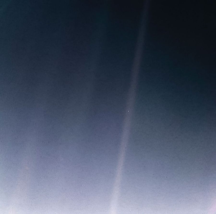
From about 6 billion kilometres from the Sun, Voyager 1 took 60 images for the first Solar System family portrait. Earth became the Pale Blue Dot. The Earth frames were recorded only 34 minutes before the cameras were permanently switched off. Camera-control software was later removed from both spacecraft so resources could support the interstellar mission.
How entry into interstellar space was established
Voyager 1 crossed the termination shock on 16 December 2004 and the heliopause on 25 August 2012. Because its plasma spectrometer had failed in 1980, the boundary was identified from sharp particle and magnetic-field changes and later confirmed through plasma-density measurements by PWS. Crossing the heliopause means leaving the Sun’s plasma bubble, not the entire gravitational Solar System.
A 3.7-metre antenna, six computers and three RTGs
Each Voyager uses a 3.7-metre high-gain antenna, S-band commands, primarily X-band telemetry and three radioisotope thermoelectric generators powered by plutonium-238 heat. Two units of each of three computer types handle commands, science data and orientation. NASA lists about 32,000 words of memory across all six computers and roughly 8,000 instructions per second.
Explore the spacecraft
For Voyager 1, the same hardware connects three different kinds of work: imaging at Jupiter and Saturn, transmitting data to Earth, and maintaining spacecraft functions through ground-commanded repairs. The examples below identify the particular equipment and the evidence for its use.
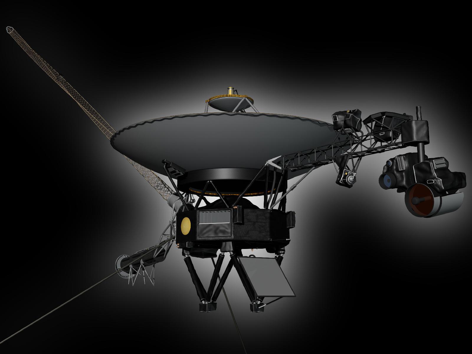
Both Voyagers have the same basic design. This original NASA illustration identifies physical components; their roles in each mission are explained below. Follow a numbered marker to its description.
HGAMain communication antenna
The 3.7-metre dish carries commands and data between the spacecraft and Earth. The attitude-control system keeps it pointed toward Earth. The large dish is a communication component; the science antennas have a different role.
Evidence: NASA Photojournal — Model of Voyager (PIA14111) · NASA — Voyager Spacecraft
CCS · FDS · AACSBody and onboard electronics
The central body contains electronics compartments. Command handling, data processing and attitude control have separate computer systems. The command system includes fault-detection and corrective routines. The computers are inside the body, rather than individually visible in this illustration.
Evidence: NASA — Voyager Spacecraft
RTGRadioisotope power generators
A separate boom carries 3 radioisotope thermoelectric generators. They supply electricity using heat from radioactive decay. The available electrical power must be shared between instruments and engineering systems, including heating.
Evidence: NASA Photojournal — Model of Voyager (PIA14111) · NASA — Voyager Spacecraft
MAGBoom for magnetic measurements
The long boom places magnetic sensors away from interference produced by the spacecraft. This separation matters when measuring weak surrounding magnetic fields. The sensor placement is part of the measurement design.
Evidence: NASA Photojournal — Model of Voyager (PIA14111) · NASA — Basics of Space Flight: Science Instruments
ISS · UVS · IRIS · PPSInstrument boom and pointing platform
The right-hand assembly carries science instruments, including cameras and spectrometers. The movable platform aims remote observations. The camera system has narrow-angle and wide-angle cameras; filter measurements can be combined to produce colour images.
Evidence: NASA Photojournal — Model of Voyager (PIA14111) · NASA — Voyager Spacecraft
PWS · PRAAntennas for plasma waves
The thin rods belong to the plasma-wave and planetary-radio experiments. They detect electrical and radio phenomena around the spacecraft. Their scientific measurements complement the data from particle detectors and magnetic sensors.
Evidence: NASA Photojournal — Model of Voyager (PIA14111) · NASA — Voyager Spacecraft
How this hardware was used
From filter measurements to a colour image
The Pale Blue Dot view uses Voyager 1 images taken through green, blue and violet filters. Those measurements were assigned to red, green and blue display channels. NASA identifies the published result as a false-colour composite. The 2020 version reprocessed the 1990 measurements; it was not a new photograph taken by the spacecraft.
Evidence: NASA Photojournal — Pale Blue Dot Revisited (PIA23645)
Moving a program in memory in 2024
A failed memory chip affected part of Voyager 1’s flight-data software. Engineers divided the affected code into sections and placed them in other memory locations, updating the references between them. This ground-directed software change restored readable engineering data. It demonstrates what could be changed remotely while the physical computer stayed aboard the spacecraft.
Evidence: NASA — Voyager 1 Resumes Sending Engineering Updates (2024) · NASA — Voyager Spacecraft
Pointing, temperature and power in 2024
Thruster pulses keep Voyager 1’s antenna aligned with Earth. When clogging required a change of thruster branch, the replacement branch needed warming. Engineers temporarily redistributed power between heaters so that the switch could be made. This documented operation links orientation control with the spacecraft’s thermal and electrical limits.
Evidence: JPL — Voyager 1 Team Accomplishes Tricky Thruster Swap (2024)
New material checked against primary sources ·
Where Voyager 1 is heading
Voyager 1 escapes at about 3.5 AU per year, roughly 35 degrees north of the ecliptic toward Ophiuchus. NASA projects that in the year 40,272 it will pass about 1.7 light-years from AC+79 3888. This is a trajectory prediction, not a targeted flyby. Reaching interstellar space also does not mean it has crossed the Oort Cloud, whose inner edge is still centuries away.
Frequently asked questions about Voyager 1
Are these Voyager 1 readings live telemetry?
The page calculates values for the current UTC from locally stored JPL Horizons vectors. It does not receive a continuous radio feed from Voyager 1. The ephemeris generation date, the calculation time and the date used to verify instrument status describe different things.
Can Voyager 1 take a new photograph of Earth?
Voyager 1's cameras were switched off after its final images in 1990 to conserve resources for other instruments. Camera-control software was later removed. The Pale Blue Dot shown here is a historical image, not a current photograph from the probe.
What was repaired on Voyager 1 in 2024?
Engineers worked around damaged memory in the Flight Data Subsystem by relocating parts of its software. Usable engineering data returned in April 2024. That historical repair is distinct from later decisions to switch off scientific instruments as electrical power declines.
How is Voyager 1 different from Voyager 2?
Voyager 1 launched later but followed a faster route past Jupiter and Saturn. Its Titan encounter sent it out of the planets' orbital plane. Voyager 2 also visited Uranus and Neptune. Their different trajectories and operating histories explain why their distances and instruments differ today.